
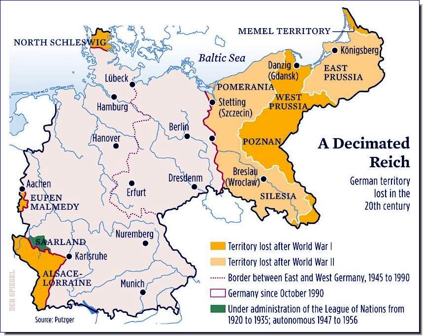
The Oder–Neisse line (Polish: granica na Odrze i Nysie Łużyckiej, German: Oder-Neiße-Grenze) is the international border between Germany and Poland. It was drawn at the Potsdam Conference in the aftermath of the Second World War and is primarily delineated along the Oder and Lusatian Neisse rivers in Central Europe, meeting the Baltic Sea to the north, just west of the Polish seaports of Szczecin and Świnoujście (German: Stettin and Swinemünde).
All prewar German territory east of the line and within the 1937 German boundaries (23.8% of the former Weimar Republic) were placed under International Law Administrative status, with most of it being made part of newly-Communist Poland. The small remainder, consisting of the territory surrounding the German city of Königsberg (now renamed Kaliningrad, in honour of Soviet head of state Mikhail Kalinin) in northern East Prussia, was allocated to the Soviet Union (as Kaliningrad Oblast of the Russian SFSR, today the Russian Federation) after the war (pending the final World War II peace treaty for Germany). The vast majority of the native German population in these territories fled, or were killed or expelled by force.
The Oder–Neisse line marked the border between the German Democratic Republic (East Germany) and Poland from 1950 to 1990. East Germany confirmed the border with Poland in 1950, while West Germany, after a period of refusal, finally accepted the border (with reservations) in 1970.
Borderlands
Incidentally, one of the possible origins for the word Ukraine is that it comes from slavic root words that translate as "borderlands".
The territorial changes of Poland

The prewar eastern Polish territories of Kresy, which the Red Army had overrun during the Nazi-Soviet invasion of Poland in 1939 (excluding the Białystok region) were permanently annexed by the USSR, and most of their Polish inhabitants expelled. As a result of the Potsdam agreement to which Poland's government-in-exile was not invited, Poland lost 179,000 km2 (45%) of prewar territories in the east, including over 12 million citizens of whom 4,3 million were ethnically the speakers of Polish. Today, these territories are part of sovereign Belarus, Ukraine, and Lithuania.
In turn, postwar Poland was assigned considerably smaller territories to the west including the prewar Free City of Danzig and the former territory of Nazi Germany east of the Oder-Neisse line, consisting of the southern portion of East Prussia and most of Pomerania, Neumark (East Brandenburg), and German Silesia. The German population fled or was forcibly expelled before these Recovered Territories (official term) were repopulated with Poles expelled from the eastern regions and those from central Poland. The small area of Zaolzie, which had been annexed by Poland in late 1938, was returned to Czechoslovakia on Stalin's orders.
This settlement was not finally agreed by Germany and Poland until the early 1990's after the re-unification of Germany in 1990.
The German–Polish Border Treaty of 1990 finally settled the issue of the Polish–German border, which in terms of international law had been pending since 1945. It was signed by the foreign ministers of Poland and Germany, Krzysztof Skubiszewski and Hans-Dietrich Genscher, on 14 November 1990 in Warsaw, ratified by the Polish Sejm on 26 November 1991 and the German Bundestag on 16 December 1991, and entered into force with the exchange of the instruments of ratification on 16 January 1992.
In the Potsdam Agreement of 1945, the Allies of World War II had defined the Oder–Neisse line as the line of demarcation between the Soviet occupation zone in Germany and Poland, pending the final determination of Poland's western frontier in a later peace settlement. This transferred regions to Poland which had been part of German states for centuries, reducing Germany to approximately three quarters of its territory as of 1937. The Treaty of Zgorzelec of 1950 between East Germany and the People's Republic of Poland confirmed this border as final. West Germany, which saw itself as the only legal successor to the German Reich and did not recognize East Germany, insisted that final settlement on the Polish–German border could only be accepted by a future reunited Germany. Although West Germany, for all practical purposes, accepted the Oder–Neisse border in the Treaty of Warsaw (1970), its legal caveat that only a future peace treaty would formally settle the issue remained in effect.
With German reunification finally within reach in 1990, the Allies of World War II made full sovereignty for Germany conditional on the final recognition of the Oder–Neisse border, as stipulated in article 1.2 of the Treaty on the Final Settlement with Respect to Germany. The signing of a treaty between Germany and Poland recognizing the Oder–Neisse line as the border under international law was also one of the terms of the Unification Treaty between West and East Germany that was signed and went into effect on 3 October 1990. Poland also wanted this treaty to end the ambiguity that had surrounded the border issue since 1945.
So, in 1992, this settlement produced an international agreement as to the territory and borders of Poland that almost exactly correspond to Poland's borders during the period of Poland's first rulers, one thousand years ago!
This
large scale map gives some idea of the territories associated with the
formation of Poland as a state at the time of its first two rulers in
the years immediately before and after the first millennium.

Poland
expanded under its first two rulers. The dark pink area represents
Poland at end of rule of Mieszko I (992), whereas the light pink area
represents territories added during the reign of Bolesław I (died 1025).
The dark pink area in the northwest was lost during the same period.
Poland was established as a state under the Piast
dynasty, which ruled the country between the 10th and 14th centuries.
Historical records referring to the Polish state begin with the rule of Duke Mieszko I who chose to be baptized in the Western Latin Rite, probably on 14 April 966, following his marriage to Princess Doubravka of Bohemia, a fervent Christian.
This event has become known as the baptism of Poland, and its date is often used to mark a symbolic beginning of Polish statehood. Mieszko
completed a unification of the West Slavic tribal lands that was
fundamental to the new country's existence. Poland was led by a series
of rulers who converted the population to Christianity, created a strong
kingdom fostering a distinctive Polish culture that was integrated
into the broader European culture.
Mieszko's son, Duke Bolesław I the Brave (992–1025), established a Polish Church structure, pursued territorial conquests and was officially crowned the first king of Poland in 1025, near the end of his life. During the Congress of Gniezno in the year 1000, Holy Roman Emperor Otto III recognized the Archbishopric of Gniezno, an institution crucial for the continuing existence of the sovereign Polish state.
Mieszko's son, Duke Bolesław I the Brave (992–1025), established a Polish Church structure, pursued territorial conquests and was officially crowned the first king of Poland in 1025, near the end of his life. During the Congress of Gniezno in the year 1000, Holy Roman Emperor Otto III recognized the Archbishopric of Gniezno, an institution crucial for the continuing existence of the sovereign Polish state.
Partition and abolition!
In
modern China "to Poland", in early twentieth century discourses about
nationhood, meant the disappearance of a state. Poland has been
abolished by so-called European "great powers" many times, resulting in
partition after partition.

The Polish–Lithuanian Commonwealth at its greatest extent, after the Truce of Deulino of 1619
However, one of the most remarkable political developments in the modern history of Europe occurred following the Union of Lublin of 1569 that established the Polish–Lithuanian Commonwealth, a federal state
more closely unified than earlier political arrangements between Poland
and Lithuania. The union was run largely by the nobility through the
system of central parliament and local assemblies, but was headed by
elected kings. The formal rule of the nobility, who were proportionally
more numerous than in other European countries, constituted an early
democratic system, "a sophisticated noble democracy", in contrast to the absolute monarchies
prevalent at that time in the rest of Europe. The beginning of the
Commonwealth coincided with a period in Polish history when great
political power was attained and advancements in civilization and
prosperity took place. The Polish–Lithuanian Union became an influential
participant in European affairs and a vital cultural entity that spread
Western culture, with Polish characteristics, eastward. In the second
half of the 16th century and the first half of the 17th century, the
Commonwealth was one of the largest and most populous states in
contemporary Europe, with an area approaching one million square
kilometres (0.39 million square miles) and a population of about ten
million. Its economy was dominated by export-focused agriculture.

No comments:
Post a Comment